Radar maps show scale of damage from Israeli strikes on Lebanon

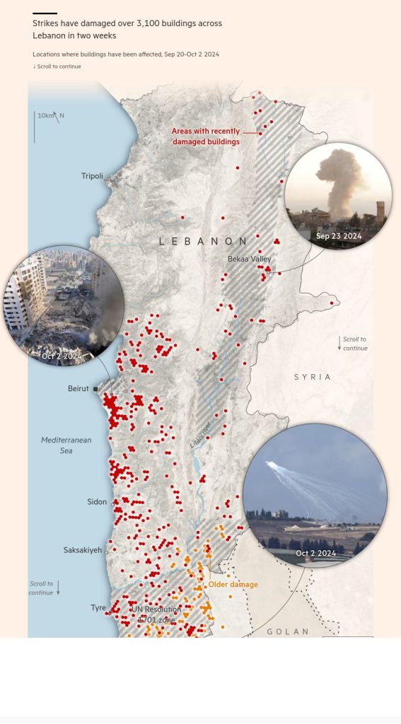
Israel’s escalating bombardments of Lebanon over the past two weeks have left a mark across the landscape: an estimated 3,100 buildings in the country have been damaged or destroyed since September 20, according to satellite-based radar measurements provided to the FT.
The strikes during this period have killed at least 1,336 people and displaced more than 1mn from their homes, according to Lebanon’s health ministry. The death toll has already exceeded that of the 2006 war with Israel, making this the deadliest conflict in Lebanon for more than three decades.
Emily Tripp, director of conflict monitoring group Airwars, said the concentrated ferocity of the campaign was almost unprecedented. “There’s a level of intensity in the strike level and the number of munitions being employed which is certainly only comparable to Gaza,” she said.
Israel’s air force struck at least 4,600 targets in Lebanon between September 20 and October 2 — sometimes more than 1,000 in a single day — according to posts on its Telegram channel. The Israel Defense Forces declined to respond to the FT’s request for additional details on the figures.
The bombing campaign is part of what the IDF says is a “new phase” of the war, which it says forms part of efforts to ensure northern Israel is safe enough to allow 60,000 people displaced by Hizbollah rocket fire to return home. The strikes came as Hizbollah sent barrages of rocket fire at Israel and fired a ballistic missile towards Tel Aviv.
Tripp said the recent figures on the Israeli bombardment exceeded even the most intensive days of the US-led campaign in Syria. “The absolute peak of the war against Isis was about 500 [targets] a day in August 2017,” she said. “And that was so bad for civilians that the United States is now overhauling its policies.”
Early reports are still insufficient to establish how many of these casualties were civilians or Hizbollah combatants. Lebanon’s health minister Firas Abiad said the vast majority of the 558 people killed in Israeli bombings on September 23 were “unarmed civilians” in their homes.
These maps show estimated damage to buildings using satellite-based radar data, provided to the FT by Corey Scher, a doctoral candidate at the City University of New York and Jamon Van Den Hoek of Oregon State University. The pair have previously estimated damage in Lebanon and northern Israel.
“Radar is sensitive to three-dimensional changes,” Scher said. “If a building collapses on itself but the roof is still intact, you might not notice it on a satellite image, but we’ll be able to tell. Similarly, damage to facades that you can’t always see from above [is] reflected in radar damage maps.”
However, Scher cautioned that these were still preliminary estimates — official surveys of damage are calculated from the ground, after a conflict.
The damage data suggests that three regions have been a particular focus of Israel’s latest offensive: destruction is concentrated near Lebanon’s southern border, in the Bekaa Valley in the east, and in the southern suburbs of Beirut, all Hizbollah strongholds.

Since Hamas attacked Israel on October 7 — after which Hizbollah began firing on Israel in “solidarity” with the Palestinian militants — Israel has bombarded infrastructure in the south of Lebanon.
The strikes have targeted what Israel said were Hizbollah facilities it believed were used to store and launch short-range missiles at Israeli towns just across the southern border. Hizbollah is believed to have dug a network of tunnels in the border region.
After waking up to the sounds of hundreds of air strikes pummelling southern Lebanon on September 23 — the day Israel dramatically escalated its aerial campaign across the country — hundreds of thousands of people began desperately streaming north.
The Israeli military has this week issued multiple rounds of evacuation orders for the region, warning civilians in dozens of villages and towns to move north of the Litani river to avoid its aerial attacks and ground invasion, which began on October 1. It issued a fresh evacuation order on Thursday, bringing the total villages to have received such instructions from the IDF this month to 70.
The data shows a sharp increase in attacks since September 20, with at least 530 buildings damaged or destroyed across dozens of towns.
The targets of the strikes have extended much further inland than the southern border areas where Israel had previously concentrated its efforts against Hizbollah over the past year — which had already resulted in extensive damage. That has resulted in many of the displaced people travelling north to Beirut, more than doubling the city’s population overnight.
The damage has not stopped at the Litani river: the town of Kfar Sir, just north of Israel’s evacuation line, had 80 buildings damaged over the two weeks, according to the estimates. The Lebanese government said it was hit at least once from the air on September 26.

The lush green valleys of this region east of Beirut have made it Lebanon’s agricultural heartland for generations. Its fertile land is also home to many of the country’s vineyards.
But it is also one of the poorest areas of the country, and is home to many of the more than 1.5mn Syrian refugees living in Lebanon, many of whom faced yet another displacement this week.
While different religious communities live side by side in the Bekaa, its Shia Muslim pockets provide deep wells of support for Hizbollah. The militant group has been known to use the area for military activities, including weapons storage. Israel says its strikes in the region targeted those sites.

The Israeli government has conducted a significant bombing campaign in the region, damaging or destroying at least 210 buildings across dozens of villages, according to the radar data.
Scher noted that this might be an undercount because the radar is prone to underestimate damage to smaller buildings in rural areas. Many of the strikes have also targeted small military installations in fields, both underground and overground, which may not appear in the damage data.

On September 27, the Israeli government killed Hizbollah’s leader, Hassan Nasrallah, in air strikes on a residential compound in Dahiyeh in the southern suburbs of Beirut. Nasrallah and several other senior Hizbollah officials were meeting at the time in what Israel said was an underground bunker
Images of the site show a large crater, covered by the rubble of the high-rise buildings that previously rose above it.
The neighbourhood has been a particular focus of Israeli air strikes in the last two weeks: an estimated 380 buildings have been damaged or destroyed since 20 September, according to the satellite data.
The IDF issued evacuation orders to residents of Dahiyeh late on September 27, identifying buildings it intended to strike. Photos from the ground reveal extensive destruction in the area, with dozens of buildings reduced to rubble.
Tripp warned that the bombardment of such a densely populated area would result in civilian casualties. “You can use the world’s most precise munitions in densely populated areas, but still have huge effects on civilians,” she said. Attacks throughout Lebanon — including in Dahiyeh — between September 16 and 27 killed at least 87 children, for example, authorities said.
In the greater Beirut area, an estimated 630 buildings were damaged or destroyed in the past two weeks, many in neighbouring areas of Dahiyeh.
The area has largely emptied out this week, as hundreds of thousands of residents fled the bombardment — moving into temporary shelters, staying with family and friends, or sleeping rough on the streets of the capital.

In Dahiyeh, the FT saw the neighbourhood’s wide alleys nearly deserted and pockmarked with craters from air strikes where high-rise buildings once stood.
Many of the collapsed buildings were in residential compounds that housed civilians, though some were linked to Hizbollah offices, including its civil infrastructure.
The group largely controls the neighbourhood, which is home to many of the group’s support base, but is also home to many others outside the Shia Muslim community.
“Dahiyeh is a ghost town. I can’t even recognise it any more,” said one resident of the neighbourhood, who has since fled and is staying in an informal shelter inside a rundown office building in downtown Beirut. “I wonder what will remain of it, when this is over?”
Additional reporting by Malaika Tapper, Chris Cook and Hirofumi Yamamoto in London, and Polina Ivanova in Tel Aviv
#Radar #maps #show #scale #damage #Israeli #strikes #Lebanon


